
Linville Falls is one of the most impressive waterfall destinations along the Blue Ridge Parkway, with several trails and overlooks offering very different views of the falls and Linville Gorge.
After being closed because of damage from Hurricane Helene, Linville Falls and its main trail system have now reopened. We recently returned to hike the trails, see what had changed, and document the current conditions. The photos throughout this updated guide are from that recent visit, so you’ll get an up-to-date look at what the area is like now.
In this guide, we’ll show you the different trails and overlooks, explain which views we think are worth the hike, and share what remains closed or different since the storm. If you’re planning a visit, keep reading. We’ll help you decide which trail to take and what to expect when you arrive.
Updated: 9/14/2026
Need to Know |
|---|
Location: Blue Ridge Parkway, North Carolina |
Accessible: Limited - Those with canes or the ability to walk for short distances may be able to do the first part of Erwin's Trail to see twin falls. |
Dog Friendly: Yes |
Distance: Approximately 0.3 to 1.65 miles round trip, depending on the trail and overlooks selected. |
Difficulty: Moderate to strenuous. Erwin’s View Trail is moderate with steeper climbs beyond Upper Falls. Plunge Basin Trail is strenuous, with steps, rocky terrain and significant elevation changes. The trail to the river remains closed. |
Features: Upper Falls, views of Lower Falls, four overlooks along Erwin’s View Trail, Plunge Basin Overlook, Linville Gorge views, Dugger’s Creek Falls, and forested hiking trails. |
Directions: Take the Blue Ridge Parkway to Milepost 316.4, turn into the Linville Falls area off the Parkway - there will be signs and it's easy to find. Take the road to the visitor's center parking area. |

Linville Falls, NC
Linville Falls is a series of cascades along the Linville River that drop approximately 90 feet before the river continues into Linville Gorge. Upper Falls begins with two side-by-side cascades, followed by a narrow rocky channel and the powerful 45-foot Lower Falls.
Several overlooks provide very different views of the waterfall and gorge. Erwin’s View Trail leads to Upper Falls, Chimney View, Gorge View, and Erwin’s View. On the opposite side of the river, the Plunge Basin Trail offers a closer view of Lower Falls. The trail leading down to the river and base of the falls remains closed because of damage from Hurricane Helene.
Visitors can park in the main paved parking area and follow the posted signs to the different trails. The former visitor center is no longer standing, but portable toilets are available near the parking area. Before beginning your hike, take a moment to look at the trail map and decide which overlooks best fit your available time and hiking ability.
Linville Falls Has Reopened After Hurricane Helene Closures
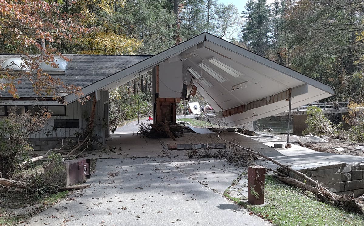
The visitor center was significantly damaged by Hurricane Helene and has been removed (see below).
Great news for anyone planning a trip to Linville Falls. The Linville Falls trail system has reopened, and visitors can once again access one of the most popular waterfall hikes along the Blue Ridge Parkway.
We returned to Linville Falls in July 2026 to see the area for ourselves, hike the reopened trails, and document the changes following Hurricane Helene. The Linville Falls Spur Road at milepost 316.5 is open and leads into the main recreation area, where visitors can access the trails and hike to the overlooks for views of Linville Falls and Linville Gorge. The photos in this updated guide are from our July visit.
There are still a few important things to know before you go. The Linville Falls campground and picnic area remain closed because of damage from Hurricane Helene. The visitor center, shown damaged above, has been removed. The park service is working on a plan to rebuild the visitor center by the end of 2027.
The Blue Ridge Parkway also still has closures south of Linville Falls. While the falls and trails are open again, this part of the Parkway has not fully returned to normal.
We recommend checking the official Blue Ridge Parkway road status page before heading out, especially if you plan to continue south on the Parkway after your visit. Conditions and closures can change as repair work continues.
Even with the remaining closures and visible storm damage, it was wonderful to return to Linville Falls and see visitors enjoying the trails and overlooks again. It is one of the most beautiful and iconic stops along the Parkway, and we are glad access to this special place has been restored.
Linville Falls Videos
Our most recent, and post Hurricane Helene video, just after Linville Falls reopened in 2026:
This video shows our visit before Hurricane Helene, in July of 2021:
Parking, Restrooms, and the Former Linville Falls Visitor Center

The former Linville Falls Visitor Center is no longer standing. The building was severely damaged by Hurricane Helene and has since been removed. Visitors can still use the main paved parking area and access the reopened trails, but the gift shop, ranger information desk, maps, and indoor restrooms that were once available inside the visitor center are gone.
Paved Parking Area
The main paved parking area is reached from the Blue Ridge Parkway. Turn onto the Linville Falls Spur Road near Milepost 316.4 and follow the road approximately 1.5 miles to the parking area.
This is the best parking area for accessing Erwin’s View Trail, Plunge Basin Overlook, and Dugger’s Creek Falls. Parking is free.
Old NC 105 Parking Area
The Linville Falls trails can also be accessed from the U.S. Forest Service gravel parking area on Old NC 105, also known as Kistler Memorial Highway. This provides another way to reach the trail system if your route makes it more convenient or Parkway access changes.
The gravel lot is smaller and has fewer facilities than the main paved parking area.
Restrooms and Other Facilities
Portable toilets are available near the paved parking area. There are no indoor restrooms, gift shop, or visitor center services. Do not count on drinking water being available, so bring enough water for your hike.
The Linville Falls campground and picnic area remain closed because of damage from Hurricane Helene. Conditions can change as repairs continue, so check the official Blue Ridge Parkway road status page before leaving home.
Linville Falls Hiking Trails

There are two main trail systems at Linville Falls, along with a short trail to Dugger’s Creek Falls. The right trail for you will depend on how much time you have, which view you want to see, and how comfortable you are with steep climbs and elevation changes.
Erwin’s View Trail is the best option for most first-time visitors. It leads to four overlooks and allows you to turn around whenever you are ready. Upper Falls is the shortest option, Chimney View provides one of the best views of the main waterfall, and Erwin’s View offers the widest view of Linville Falls and the gorge.
The Plunge Basin Trail is shorter but more strenuous, with steep sections and steps leading to a closer view of Lower Falls. The Linville Gorge Trail branches from this route and continues down to the river. The Linville Gorge Trail has officially reopened.
The distances below are approximate round-trip distances from the paved parking area.
Trail or Destination | Details |
|---|---|
Erwin’s View Trail | 1.65 miles round trip. Moderate and open. Leads to Upper Falls, Chimney View, Gorge View, and Erwin’s View. |
Plunge Basin Overlook | 1.18 miles round trip. Strenuous and open. Provides a closer side view of Lower Falls. |
Linville Gorge Trail | Normally 1.4 miles round trip. Strenuous and currently closed beyond the junction because of Hurricane Helene damage. |
Dugger’s Creek Falls | About 0.3 mile round trip. Moderate in current conditions and open. Leads to a small waterfall viewed from a bridge. |
Erwin's View Trail

Erwin’s View Trail is a moderate 1.6-mile round-trip hike that leads to four overlooks, each offering a different view of Linville Falls, the Linville River, and Linville Gorge. This is the most popular trail at Linville Falls and the best choice if you want to see the falls from several different angles.
The first part of the trail to Upper Falls is fairly easy, but the hike becomes steeper and more challenging as you continue toward Chimney View, Gorge View, and Erwin’s View. You do not have to complete the entire trail to enjoy it. You can visit one or two overlooks and turn around, or continue to the end for the widest view of the falls and gorge.
During our recent visit, the trail itself was clear and easy to follow. However, we saw numerous downed trees along both sides of the trail, which were visible reminders of the damage caused by Hurricane Helene. Overall, we were very impressed with the condition of the trail and how well it had been cleared, repaired, and maintained by park staff.
The full hike is well worth doing if you have the time and are comfortable with the elevation changes. Along the way, the trail passes through a beautiful wooded area and gives you everything from an up-close look at the river to wide views across Linville Gorge.


Upper Falls

Upper Falls is the first overlook along Erwin’s View Trail. This is the easiest section of the trail, with only a slight change in elevation. The trail follows the Linville River and crosses a bridge before continuing along a dirt path. Watch for a short side trail on the left that leads down to the Upper Falls viewing area.
From the overlook, you can watch the Linville River flow over two side-by-side cascades and into a pool. The river then narrows, rushes through a small rocky gorge, and continues toward the 45-foot drop of Lower Falls.
Swimming is not allowed at Upper Falls, and the fast-moving water and steep drop make this area extremely dangerous. Stay behind the retaining walls and never climb over them. A slip into the river here could be fatal.


Chimney View

After visiting Upper Falls, return to the main trail and continue toward Chimney View. The overlook is about 0.2 miles farther along the trail. This section passes through a beautiful forested area and becomes steeper as you climb, making it more challenging than the walk to Upper Falls.
Chimney View is the first overlook where you can clearly see the main drop of Linville Falls. From here, you can watch the Linville River flow through Upper Falls, narrow between the rocks, and then plunge into the large basin below. You will also have a wonderful view of the surrounding cliffs and the beginning of Linville Gorge.
The overlook gets its name from the chimney-shaped rock formations near the waterfall. It is one of the best places along the trail to photograph the falls because you can see both the upper and lower sections from the same viewpoint. The surrounding rock formations and forest also help to show the size and ruggedness of the gorge.
Take some time to enjoy this overlook before continuing. The view here is closer and more dramatic than the distant view from Erwin’s View, making Chimney View one of our favorite stops along the trail.
Gorge View
Gorge View is located between Chimney View and Erwin’s View. Unlike the other overlooks, the main attraction here is not the waterfall. This overlook looks downstream as the Linville River continues through the steep and rugged Linville Gorge.
It is a worthwhile stop because it gives you a better sense of the depth and size of the gorge. After enjoying the view, return to the main trail and continue a short distance to Erwin’s View, the final overlook along the trail.
Erwin's View

After visiting Gorge View, return to the main trail and continue a short distance to Erwin’s View, the final overlook along the trail. Once you have enjoyed the view, you will return to the parking area along the same trail.
Erwin’s View offers the widest and most expansive view of the Linville Falls area. From this higher vantage point, you can see both Upper Falls and the main waterfall in the distance, along with the Linville River winding through the rugged landscape. The view also stretches across Linville Gorge, giving you a much better sense of just how large and deep the gorge really is.
The waterfall is farther away here than it is at Chimney View, but the surrounding scenery makes this overlook well worth visiting. It is an especially beautiful view when the mountains are covered in spring green or fall color. A zoom lens (used in the above photo) can help if you want a closer photograph of the falls, while a wider lens is better for capturing the waterfall and gorge together.
Erwin’s View is a wonderful place to rest and enjoy the scenery before beginning the hike back. If you have made it this far, take your time. This is the broadest view along the trail and a fitting end to the hike.
Linville Gorge - Plunge Basin Trail

The trail leading toward Plunge Basin begins near the site of the former Linville Falls Visitor Center. After approximately 0.2 mile, the trail splits into two routes.
The right fork leads to Plunge Basin Overlook and is currently open. This strenuous, approximately one-mile round-trip hike includes steep sections, steps, rocky terrain, and noticeable elevation changes. The overlook provides a closer view of the lower falls and the surrounding rock formations.
The left fork is the Linville Gorge Trail, which descends to the Linville River near the base of the falls. This portion of the trail remains closed because of damage from Hurricane Helene. Do not enter the closed section or attempt to reach the river from this route.
We did not hike to Plunge Basin Overlook during our July 2026 visit, and it has been several years since we last explored these trails ourselves. Any older photos shown below are from those previous visits. Check the posted signs and the current National Park Service trail map before beginning your hike, since closures may change as repairs continue.
Dugger's Creek Falls

Dugger’s Creek Falls is a small waterfall located near the Linville Falls parking area. One quick pronunciation note: Dugger’s is pronounced “Doug-ers,” with “dug” sounding like the word in “I dug a hole.”
The trailhead is near the back corner of the parking area. Look for the small trail leading into the woods. The hike is short, but we would consider it moderate because of the uneven ground, rocks, roots, and current storm debris. The trail leads to a wooden bridge that crosses Dugger’s Creek and provides the easiest and best overall view of the falls.

During our July 2026 visit, this was where we saw some of the most visible damage from Hurricane Helene. Below the falls, near the parking area and road, the creek had been heavily washed out. So many trees were lost that you can now almost see Dugger’s Creek from the parking area. Before the storm, the creek was mostly hidden behind the trees and surrounding vegetation.
We also saw numerous fallen trees along the trail. The area below the bridge looked very different from our previous visits. It was much more open, with fallen trees, limbs, and other debris scattered through the creek. The storm dramatically changed the appearance of this once heavily wooded area.
The bridge provides a clear view of the waterfall and is the safest place for most visitors to enjoy and photograph it. In the past, photographers could get an exceptional view by carefully making their way below the bridge. That area is now much more difficult to reach because of the fallen trees and debris. Conditions may also be unstable, so do not climb over debris, leave the designated trail, or attempt to reach the creek if the route is closed or unsafe.
Although Dugger’s Creek Falls is much smaller than Linville Falls, it is still worth the short walk. The waterfall remains beautiful, but the surrounding landscape now offers a striking look at how much Hurricane Helene changed this area.
Tips for Visiting Linville Falls
A little planning can make your visit to Linville Falls safer and more enjoyable, especially while repairs from Hurricane Helene continue.
- Check road and trail conditions before leaving. Portions of the Blue Ridge Parkway and the Linville Falls recreation area may still be closed. Check the official Blue Ridge Parkway road status page for the latest information.
- Arrive early if you can. Linville Falls is one of the most popular stops along the Parkway, and the parking area can fill quickly on weekends and during fall color season.
- Prepare for changing mountain weather. Linville Falls can be cooler, wetter, and windier than nearby lower elevations. Check the forecast for the Linville Falls area, dress in layers, and bring a light rain jacket even if conditions are warm and sunny when you leave.
- Wear comfortable hiking shoes. Erwin’s View Trail is well maintained, but it includes roots, rocks, steps, and steeper climbs beyond Upper Falls. Recent rain can also leave parts of the trail wet or muddy.
- Bring water and anything else you may need. The former visitor center is gone, and you should not count on drinking water, food, maps, or other supplies being available.
- Choose the overlooks that work for you. You do not have to hike the entire Erwin’s View Trail. Upper Falls is the easiest and quickest option. Chimney View requires more climbing, but we think it provides the best overall view of Linville Falls.
- Allow enough time. Plan on about one to two hours for Erwin’s View Trail, depending on how many overlooks you visit and how long you spend enjoying the views and taking photos.
- Stay behind all walls, railings, and barriers. The Linville River has a strong current, slippery rocks, and dangerous drops. Swimming and wading are not allowed, and getting too close to the water can be fatal.
- Keep children close. Several overlooks have steep drop-offs, and Upper Falls is especially dangerous because of the fast-moving water.
- Keep pets leashed. Dogs are allowed on the trails but must remain on a leash. Bring water for them and clean up after them.
- Expect limited cell service. Download directions or save the parking coordinates before arriving, especially if you plan to approach the area using Old NC 105.
- Leave No Trcace. Carry out all trash, remain on marked trails, and avoid climbing around fallen trees or entering closed areas.
