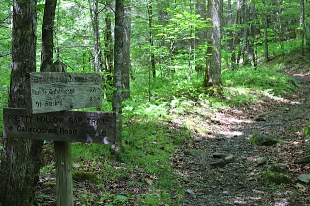
Our first hiking trip in Cataloochee Valley was out Pretty Hollow Gap Trail. Pretty Hollow Gap Trail is a 8 mile round trip out and back trail, that follows along side Palmer Creek and Pretty Hollow Creek to Pretty Hollow Gap, where the trail ends and runs into Mount Sterling Ridge Trail and Benton MacKaye Trail, a nearly 300 mile long trail.

Pretty Hollow Gap Trail – Cataloochee Valley
Location: Cataloochee Valley in The Great Smoky Mountains National Park
Roundtrip Distance: 8 miles
Difficulty: Moderate
Features: Creekside
Directions: From I40, take exit 20 for Maggie Vally, and make an almost immediate turn right onto Cove Creek Road. Follow Cove Creek and continue on it even after it becomes a gravel road. Once your reach pavement again, turn left and follow the road to the trail head into Cataloochee Valley. The trailhead is located just before the schoolhouse and bridge on the right. You’ll see the metal gates preventing car traffic, and the trailhead is a gravel road. Just a heads up, Cove Creek Road is considered by most to be a crude dirt/gravel road, full of twists and turns and large pot holes. The road is also very narrow, and only wide enough for one car, so go slow and take your time.
Recommended Gear: Good hiking boots or shoes, Daypack, Dayhiker First Aid Kit, hiking rain ponchos, some snacks, water, a camera and [easyazon_link asin=”B0054NFYDG” locale=”US” new_window=”default” nofollow=”default” tag=”blueridgemountainlife-20″ add_to_cart=”default” cloaking=”default” localization=”default” popups=”default”]bug repellent[/easyazon_link]
Pretty Hollow Gap trail is an decent hike, due to following along side Palmer and Pretty Hollow Creek in Cataloochee Valley. The trail itself however is pretty rough in some areas, and not frequently traveled or maintained. The trail is also a popular horse trail, meaning you need watch out for manure as you hike and pretty muddy and rough in some areas due to their hooves. Some of the trail sections are really nice, but others are pretty bad.
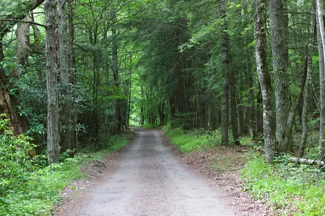
The first part of the trail is a gravel road that takes you past the horse camping area. At the end of the road, you’ll see the pretty rough looking trail going up next to the creek. The trail has lots of erosion areas, roots, rocks, mud, and black soupy areas. This is particularly bad after a recent rain, which is pretty common in The Great Smoky Mountains National Park.
While not a steep climb overall, the trail does climb 2,100 feet in 4 miles. Most of that is on the last 1.5 miles as the trail approaches Mount Sterling Ridge Trail and begins to climb Mount Sterling.
Pretty Hollow Gap Trail is also the initial trail you take to hike Little Cataloochee trail, a popular trail in the park.
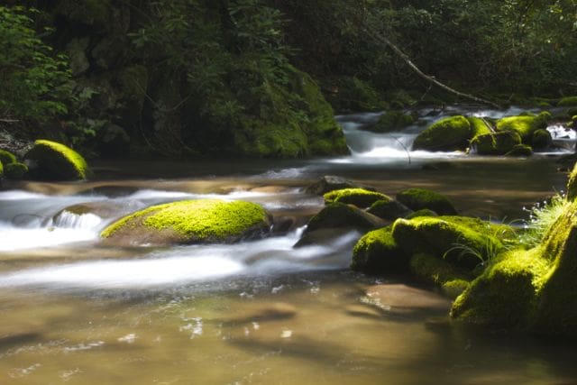
The trail follows along side Palmer Creek initially, and then later Pretty Hollow Creek. Pretty Hollow Creek is crossed three times. Two of the crossings are bridged, but the third requires a little rock hopping to stay dry. We stopped often at various creek access points to enjoy the water and take a break.
We arrived at Pretty Hollow Gap and Sterling Mountain Trail a bit winded. Took a snack and rest break, then headed back down Pretty Hollow Gap Trail and returned to our car. Unfortunately we didn’t encounter any wildlife on this trip.
Pretty Hollow Gap Trail isn’t our favorite trail in Cataloochee. We far prefer Caldwell Fork and The Boogerman Trail loop or Rough Fork Trail.