Upper Falls Graveyard Fields is a nice waterfall and hike. The waterfall is accessed by a 1.5 mile hike, that gets a little steep towards the end, but provides you with a nice overview of Graveyards Fields an what it has to offer.
Roundtrip Distance: 1.5 Miles
Handicap/Disability Accessible: No
Difficulty: Easy/Moderate, most of trail is easy, however the last .25 miles or so is moderate
Features: Unique Plantlife and scenery, blueberry field, waterfall, gorgeous fall colors
Directions: Located on the Blue Ridge Parkway at milepost 418.8 between Asheville and Waynesville NC. There is a large parking lot for the area and a bathroom building. It will be hard to miss.
Recommended Gear: Good hiking boots or shoes, Daypack, Dayhiker First Aid Kit, Sunscreen, [easyazon_link cloaking=”default” keywords=”hiking rain poncho” localization=”default” locale=”US” nofollow=”default” new_window=”default” tag=”blueridgemountainlife-20″]hiking rain ponchos[/easyazon_link], some snacks, plenty of water and be sure to bring a bathing suit if you think you might want to swim.
Map:
Upper Falls Graveyard Fields
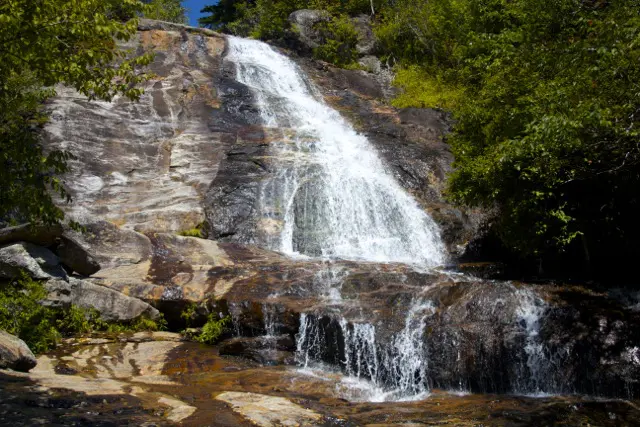
Upper Falls Graveyard Fields isn’t a fantastic waterfall, but it does make for a nice destination and a great hike. Graveyard fields is a unique location on the parkway, with unique plants and scenary. This particular trail offers one of the best overviews of Graveyard fields, and the many things it has to offer.
From the Parking Lot at MP418.5, you’ll want to take the main trail head next to the bathroom facilities, going down the rock stairs. Follow the paved trail until turns into wooden decking and some stairs going down. You’ll cross over Yellow Prong, which is the water source for both Upper and Lower Falls, and Skinny Dip Falls (further down the Parkway) as well. After crossing Yellow Prong, continue on the trail, and you’ll see a trail going up and to your left. This is the trail for Upper Falls.
Follow this trail for about a mile to reach Upper Falls.
The trail traverses through the low brush of Graveyard fields and carries you through numerous blueberry bushes and other short growth brush, trees and wildflowers. In fact, Graveyard Fields is an extremely popular place during the Fall to pick blackberries.
The trail through this area is a bit rough a times, especially if it’s been raining. There had been a lot of rain prior to our recent hike, and trail was full of mud and water. The trail is also very narrow and crosses over a few streams on the way up to the falls. While not the best trail, Upper Falls Trail is a nice hike worth the hike.
One point of frustration is that the trail is not well marked, and often a bit confusing. To stay on course, just stay on the larger and wider trails. If you see a branch with a larger trail going one way, and a smaller trail going another, stay on the larger trail. You will have to cross over a few creeks by “rock hopping”.
 You’ll know you’re headed in the right direction when the trail eventually starts to lead into a forest and begins an upward climb with lots of large rocks. Continue climbing, and you’ll begin to hear the distant sounds of the water and soon emerge into an area where the lower portion of upper falls is visible. This is a great location for relaxing on the rocks, and wading in the water.
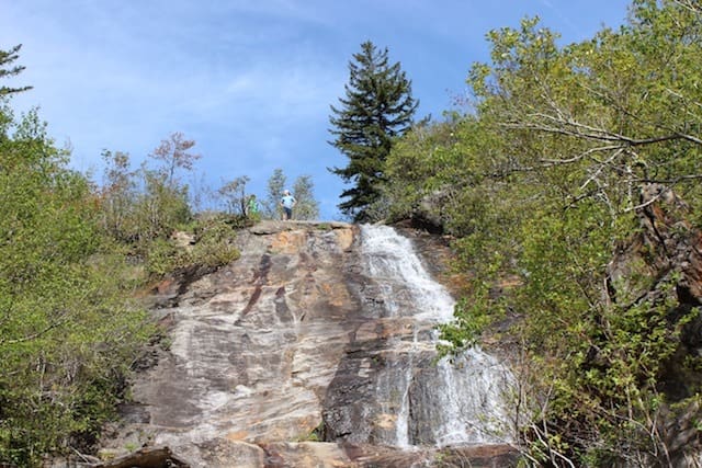
Higher up from though is the “real” Upper Falls, a beautiful cascade that is definitely worth the hike. From the lower portion, there are a couple of trails that head up the mountain. Take one of them up to the “upper” portion of Upper Falls.
Just be really careful, the rocks can be slick. Remember, you’re a long way from medical assistance, so don’t take any unnessesary chances.
We spent a good 1 – 2 hours here at the falls, enjoying the sites and sounds, taking pictures and eating lunch. We definitely didn’t want to leave.
Upper Falls Graveyard Fields Video
After relaxing and eating some lunch, we put our backpacks back on and headed back down the trail to the parking lot. For the return trip, you can just follow the same path you took up to return. You can also take a slightly different path back up, by turning right at the new bridge over yellow prong, and climb back up to the far side of the parking lot.
Upper Falls Graveyard Fields Photo Gallery
[ngg_images source=”galleries” container_ids=”55″ display_type=”photocrati-nextgen_pro_masonry” size=”180″ padding=”10″ display_type_view=”default” ngg_triggers_display=”always” captions_enabled=”0″ captions_display_sharing=”1″ captions_display_title=”1″ captions_display_description=”1″ captions_animation=”slideup” order_by=”sortorder” order_direction=”ASC” returns=”included” maximum_entity_count=”500″]